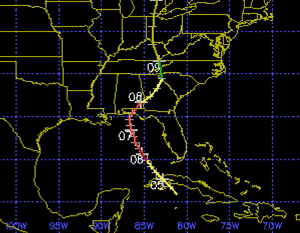
To find storms that resemble Isaac, we may have to go back to 1896 and 1903. In July 1896, a tropical storm moved north off the Cuba coast, then strengthened into a category-2 hurricane before making landfall between Pensacola and Panama City, Florida. In September 1903, a category-1 hurricane made landfall in eastern Florida, near Palm Beach, then diminished into a tropical storm as it crossed the state, emerged into the Gulf of Mexico south of Tampa, then strengthened into a category-1 hurricane before "turning the corner" near Cape San Blas, and making landfall near Panama City. The tracking maps for these storms are provided below. Yellow indicates tropical storm strength, while red indicates hurricane-force strength. Source: Unisys Corporation.
The July 1896 hurricane
The September 1903 hurricane
Surge history associated with these storms
The 1896 storm most likely produced a 10-foot surge near Dune Allen Beach, Florida. This surge event was recently removed from the official SURGEDAT database because it is speculative and based on damage reports. The 1903 storm produced a 10-foot storm tide at Apalachicola.
It is interesting that these events produced surges this high, particularly the 1903 event that emerged over the Gulf of Mexico for a limited time and never exceeded category-1 strength. These relatively high levels may be further evidence that the "Big Bend" area of Florida, particularly from Apalachicola east, is an area that experiences enhanced surge levels. The shallow offshore water and concave-shaped coast pile up water very effectively in this region. According to the current NHC forecast, Isaac should spend more time over open water than the 1903 storm and reach greater intensity. This could be of concern to people in the Florida Panhandle and Big Bend area of Florida, as the 1903 storm produced a 10-foot storm surge.
Finally, let's close with some quotes from that dusty 1896 newspaper. Although we haven't seen any direct surge measurements from that storm, we do have some interesting anecdotal accounts and we know the surge was extensive. Keep in mind the 1896 most resembles Isaac's forecast at this point, so consider these conditions may possibly repeat themselves, minus the loss of bathhouses. Thank God we have showers now.
The Daily News (Pensacola, FL), July 7-8, 1896
[My comments are bracketed]
[July 7]
What will doubtless prove the most disastrous storm that
ever visited Pensacola is prevailing as this is being written.
All is havoc along the water front and in the shipping.
In a comparatively mild form the hurricane had been howling
from the northeast all night. [This means the storm tracked E of Pensacola]
The sea was breaking over all the wharves. The little piers
extending laterally from the main structures were awash, the sea in many
instances lifting heir piling from the bottom and swaying them to and fro as
they floated.
It is impossible to even approximate the damage resultant,
but the figure will be a considerable one.
All the bath houses in the east end have been washed away.
[July 8]
It is impossible now to estimate the amount of damage in
dollars and cents to property, but it must be very large, some estimates
placing it as high as quarter of a million dollars.
Nearly every tin roof in the city was either blown off or
badly damaged.
The worst damage was to the wharf which was torn up.
The train on the P. & A. road that left for River
Junction yesterday morning, had to return to the city, the track being washed
up all along the bay shore.
The wharf and bath house fronting W.S. Keyser’s residence
near Palmetto beach, were destroyed.
Parties who came by boat from the navy yard this morning
report the Bauer’s wharf, the new wharf at Fort Barrancas, the watch houses in
the navy yard and boat houses along the beach, were either blown or washed
away. Several small houses were blown down in Warrington, but no one was
injured.
A widely picturesque scene was presented along the western
bay shore yesterday afternoon- fences down, dwellings flooded, trees uprooted,
boats high ashore and men, women and children wading waist deep in water
capturing drift timber and fire wood.
Herron’s wharf was washed away and is a total loss.
Bronnum’s wharf was carried completely away and part of his
railroad track was found down the beach in front of Burke’s house.
Walter’s boat house, one of the largest on the water front,
was completely wrecked and washed away.
Every house on Perdido wharf was leveled to the ground.
The highest wind velocity, 72 miles, was reached at 1:10
p.m. At that time the wind was northwest.


No comments:
Post a Comment