Estimates on Super Typhoon Haiyan’s massive storm surge
height have improved through shared field observations and online
collaboration.
Yesterday, I posted some photos sent to me by Aslak
Grinsted, from the Niels Bohr Institute in Copenhagen, Denmark. Aslak had sent
me photographs, which clearly showed the height of tree bark removal on trees
in the surge impact zone.


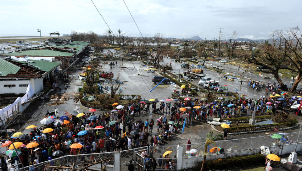
How high was Super Typhoon Haiyan's destructive storm surge? Field observations and online collaboration are starting to provide some early estimates. Image: AP Photo/ Philippines Air Force
Just a few hours later, I received the following email from
Vinny Burgoo, who was familiar with the area, knew the locations of the photos,
and had some insight into the ground elevation.
Here is the e-mail:
Hi, Hal!
I've just read your blog about Aslak
Grinsted's surge estimates for Typhoon Haiyan. Image #1 shows the southern end
of the car park for Daniel Z. Romualdez Airport outside Tacloban City. Image #2
shows a queue at its northern end. See...
...(and the pix at Skyscraper City, below).
Image #1's generators and the red collapsed slide or whatever it was are
visible at the far end. Image #2's crumpled corrugated iron is visible in the
foreground.
Image #3 is looking west across the northern
end of the car park - and it *is* the same tree as in Image #2.
Elevation? The runway is said to be 3.0 m
above MSL. An engineer's plan says a point just north of the terminal is
'2.253' - presumably m above MSL. The plan is near the end of this page:
More pix of the post-typhoon airport are at
the end of that thread.
Hope this helps a bit.
Regards,
Vinny Burgoo
Vinny mentioned that all three photographs
were taken from the airport area. Image #1 on yesterday’s blog post was from
the southern end of the carpark, while images 2 and 3 were taken from the
northern end of the carpark.
The last link provides an architectural plan
for proposed airport construction. Points on the map, accompanied by numbers,
apparently show elevation levels. The map is oriented so right of the map is facing north.

This architectural map of the Tacloban Airport reveals elevation markers of 2.253 m (7.39 ft) very close to the location of the photographs sent in from Aslak Grinsted. Ground elevation values are essential for estimating surge heights when using high water marks or tree bark removal. Image: http://www.skyscrapercity.com/
Three points on the map just south of the
carpark are given an elevation of 2.253 m (7.39 ft), including the roundabout
that is adjacent to the south end of the parking lot. This elevation seems like
a reasonable estimate for the ground level in the photos, however, additional
elevation information from multiple sources would be helpful for verification.
In image #2, Aslak estimated the surge height
as 2 human heights, and in image #3, he estimated 2.5-3 human heights.
According to Vinny, this is the same tree, located near the north end of the
carpark. It goes without saying that it is difficult to make such estimates
from photos taken at a distance, and Aslak did a great job by finding a few
photographs with people in the picture to provide scale.

Locations of the photographs from Aslak Grinsted, posted on yesterday's blog. Vinny Burgoo identified the locations of all three photos, placing them at different ends of the airport carpark. Image: Google; Photo Markups: Hal Needham
If we assume the height of the tree bark
removal reaches to 2.5 human heights, and we assume that the average adult
human height in the photograph is approximately 1.7 m (5 feet 7 inches), then
we receive an approximate elevation of 4.25 m (13.94 ft) for the height of tree
bark removal above ground level.
However, the surge was higher than this
level, because it took a certain amount of storm surge for the water to rise from Mean Sea Level (MSL) to ground level. Thus, we should add the ground
elevation to our height. Adding 2.25 m (7.38 ft) to the water height gives us
6.5 m (21.33 ft), which we may use as a rough estimate of the surge height in
this area.
Josh Morgerman submitted an Icyclone Chase
Report to document the observations that he took alongside James Reynolds and Mark Thomas, from the
Hotel Alejandro, in the heart of Tacloban City’s downtown district. The team
was able to provide a storm surge observation, as the hotel they were staying
in was inundated with water.
Quote from report:
“The storm surge rose very suddenly and
rapidly, and it peaked near or after the center’s closest approach. The hotel
flooded to a depth of ~4 ft. If the elevation at this location is truly 26 ft-
as indicated by USGS- that suggests a storm surge of up to ~30 ft. It’s
possible the elevation may have been as low as 15 ft, in which case, the surge
was ~20 ft.”

The Icyclone Chase Team took storm observations from the Hotel Alejandro, in the heart of downtown Tacloban, about 15 nm north of the landfall location. Source: Icyclone Chase Report- Preliminary
If the surge did indeed reach 30 feet (9.144
m) in downtown Tacloban, that water height would have been extraordinary, and
would have smashed the previous surge record of 7.3 m (23.95 ft) for the
Philippines and all of East Asia. The good news here is that we have a water
height measurement from a fixed location, where the structure survived the
storm. It will just take some time to verify the elevation of this hotel, in
order to increase the confidence of this measurement. Google Earth provides an
elevation of 7.32 m (24 feet) for the area near this hotel, which would provide
a surge level of 28 feet (8.53 m). The Icyclone Chase Report does mention the possibility that the surge level could have been as low as 6.1 m (20 feet) in their location.

Early surge estimates are 6.5 m (21.33 ft) at the airport and 8.53-9.14 m (28-30 ft) in downtown Tacloban. Elevation estimates for the downtown observation is uncertain, the surge height in that location may be as low as 6.1 m (20 ft). Image: Google; Photo Markups: Hal Needham
Storm surge data often are provided from different sources with different measuring techniques. In this case, some observations are starting to come in, however, there is still quite a bit of uncertainty with these observations, and the values at this point are only rough estimates. It will be very helpful to verify the elevation of Hotel Alejandro, and any other high watermarks from buildings in the area that survived the storm.
The surge estimate at the airport appears to have more accurate ground elevation information, however, the height of the tree bark removal depends on
human height as a comparison. Meanwhile, the downtown observation has a more
accurate read on the water level in the structure, however, the elevation at
that location is more uncertain.
Commonly, when reconstructing a storm surge inundation, various observations
have their strengths and weaknesses regarding accuracy of measurement. At this
point, these surge estimates are very preliminary and are beginning to paint a
picture of a surge that inundated this region with perhaps a 7.5 meter (24.6
foot) surge- give or take approximately several feet (one meter).
Estimates will improve as more information becomes available. Thanks so
much to all who contributed by doing fieldwork, sending photos, or helping with
photo interpretation.
No comments:
Post a Comment