A
complex flood event threatens Texas and Louisiana over the next several days. A
combination of a slow-moving front, the availability of ample moisture, and
prolonged onshore winds will put Southeast Texas and South Louisiana on alert
through the weekend.
Low
pressure is forming along a slow-moving front in Texas, which is serving to
pump tremendous amounts of moisture from the Gulf of Mexico. The remnants of
Hurricane Patricia, which struck Western Mexico yesterday as a category-5
hurricane, will add even more moisture to this developing flood event in Texas
and Louisiana.

National Weather Service radar depicts ample moisture streaming into Texas from the south and southwest as of Saturday morning. Moisture will pump into coastal Texas for at least two more days.
Image: http://radar.weather.gov/Conus/southplains_loop.php.
Patricia
became the most intense reliably-measured hurricane in history, as it produced maximum sustained winds of 200 mph (322 kph), before weakening as it neared the
coast (Masters 2015). The storm generated severe wind and flood damage, particularly west of
Manzanillo.

Hurricane Patricia flooded the city of Manzanillo with heavy rain and storm surge on Friday, October 23.
Image courtesy Erick L via @sandhyaABC7 on Twitter.
Although
Patricia’s winds will not directly impact Texas, its moisture will help create
phenomenal rains, particularly near the U.S. Gulf Coast. NOAA’s Quantitative
Precipitation Forecast map depicts a widespread area of rain will exceed 6
inches, particularly along and to the south of the I-10 corridor in Texas and
Southwest Louisiana over the next two days. This forecast predicts a maximum
value > 11" along the Houston- Galveston corridor.
The Houston-Galveston National Weather Service Forecast Office (NWS Houston) predicts that rainfall rates could exceed 3"/ hour along coastal Texas Saturday night and Sunday.
The Houston-Galveston National Weather Service Forecast Office (NWS Houston) predicts that rainfall rates could exceed 3"/ hour along coastal Texas Saturday night and Sunday.
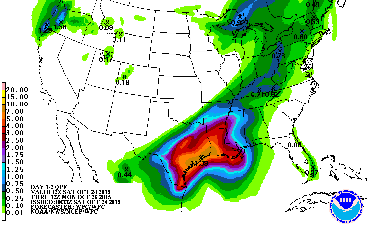
NOAA's Quantitative Precipitation Forecast predicts a widespread area will receive more than 6" of rain along coastal Texas and Louisiana, with maximum amounts exceeding 11" near Houston- Galveston.
Image: http://www.wpc.ncep.noaa.gov/qpf/day1-2.shtml.
An
extended storm surge event, which will produce water levels noticeably above
normal high tide levels, will exacerbate flooding near the coast and even
inland. Water levels at Galveston’s Pier 21 have been running more than 1 foot
(0.3 m) above normal over the past several days.
High
water levels and surf were noticeable already on Friday morning, as waves
reached the seawall. I took the photo below on the Galveston Seawall yesterday
morning. Several locals at the Living on the Edge Conference told me that water
gets that high about one time per year.

Onshore winds drove sea water to the base of the Galveston Seawall on Friday morning. Locals said this happens about one time per year. Photo: Hal Needham
NWS Houston predicts that water
levels could reach as high as 4.8 feet (1.46 m) above a datum called Mean Lower Low
Water (MLLW), particularly on Sunday. This level would be approach 3 feet above
predicted tide levels (if we take away the storm). The highest water over the past
several days was approximately 3 feet (0.91 m) above MLLW at Galveston Pier 21, or about
1.3-1.5 feet (0.4-0.46 m) above normal.
Although
a 3-foot (0.91m) storm surge is not phenomenal for Galveston, a prolonged 2-3 foot (0.6-0.91 m)
surge could have dire impacts if accompanied by 10 or more inches of rain. Most
drainage around the Houston- Galveston area is gravity-fed, meaning the
drainage depends on a noticeable slope between the ground and the water body
into which the rainwater is discharged, like a bayou, channel, Galveston Bay or
the Gulf of Mexico.

Water levels at Galveston's Pier 21 have been running around 1.3-1.5 ft (0.4-0.46m) above normal over the past few days. This has produced maximum storm tides of around 3 ft (0.91m) above MLLW. The National Weather Service predicts tide levels could reach 4.8 ft (1.46m) above MLLW this weekend, which would be as much as 3 ft (0.91m) above normal.
If
Galveston Bay is elevated 2-3 ft (0.6-0.91m) above normal, the slope between land and
water is reduced considerably, making rainfall drainage less efficient. This
becomes a major concern when looking at the extraordinary rainfall in the
forecast.
The
combined flood risk from heavy rainfall and heightened seas has been a focus of
new research in the past several years, and certainly relates to climate
change, as melting glaciers and thermal expansion push sea levels upward. Dr.
Thomas Wahl and colleagues recently published a paper (Wahl et al. 2015) proving that combined
flooding from heavy rainfall and heightened sea levels was becoming more common
along the U.S. Gulf and Atlantic Coasts.
I
will be in the Houston- Galveston area through this weekend, as I attempt to
document this complex flood event. Feel free to shoot me an email or contact me
on Twitter with any questions or comments. Also, always feel free to send in
pics or videos from coastal flood events around the world.
REFERENCES
Masters, J., 2015: Category-5 Hurricane Patricia Hitting Mexico's Pacific Coast. Blog post from Friday, October 23, 2015. Link: http://www.wunderground.com/blog/JeffMasters/comment.html?entrynum=3166.
Wahl, T., S. Jain, J. Bender, S.D. Meyers, and M.E. Luther,
2015: Increasing risk of compound flooding from storm surge and rainfall for
major US cities. Nature Climate Change,
doi: 10.1038/nclimate2736.
No comments:
Post a Comment